File:El Tajin, Pyramid of the Niches (20498729900).jpg

Original file (4,988 × 3,308 pixels, file size: 9.9 MB, MIME type: image/jpeg)
Summary
| Description |
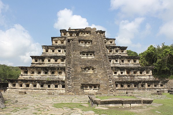
El Tajin, Pyramid of the Niches (east side) El Tajin is a pre-Columbian archeological site in southern Mexico and is one of the largest and most important cities of the Classic era of Mesoamerica. A part of the Classic Veracruz culture, El Tajin flourished from 600 to 1200 C.E. and during this time numerous temples, palaces, ballcourts, and pyramids were built. El Tajin was named a World Heritage site in 1992, thanks to its cultural importance and its architecture. This architecture includes the use of decorative niches and cement in forms unknown in the rest of Mesoamerica. Its best-known monument is the Pyramid of the Niches, but other important monuments include the Arroyo Group, the North and South Ballcourts and the palaces of Tajin Chico. In total there have been 20 ballcourts discovered at this site, (the last 3 being discovered in March 2013). The Pyramid of the Niches is also known as Pyramid of Papantla, Pyramid of the Seven Stories and the Temple of the Niches. It has become the focus of the El Tajin site because of its unusual design and good state of preservation. It was prominent in ancient times as well. A large quantity of sculpture was recovered from this pyramid. The building is mostly constructed of carefully cut and crafted flagstones, the largest of which is estimated to be about eight metric tons in weight. The stones, especially around the niches are fitted together as to need a minimum amount of lime and earth mortar. The structure originally was covered in stucco which served as the base for paint. The pyramid has seven stories. Each of these consists of a sloping base wall called a talud and a vertical wall called a tablero, which was fairly common in Mesoamerica. What is unusual about this construction and others in the city are the addition of decorative niches with the top capped by what Jose Garcia Payon called a "flying cornice," a triangular overhang. The stones are arranged in controlled lines and delicate proportions. Originally the structure was painted a dark red with the niches in black intended to deepen the shadows of the recessed niches. Niches are also found underneath the stairway along the east face, which indicates that the stairway was a later addition. The niches on the original structure, not counting those on the later stairway, total 365, the solar year. At the top of the pyramid there were tablets framed by grotesque serpent-dragons. The ritual function of the building is not primarily calendaric. The deep niches imitate caves, which long have been considered to be passageways to the underworld, where many of the gods reside. The most important part of the structure was the temple that was on top of this pyramid; however, this was completely destroyed and little is known about what it might have looked like. Sculpture from the temple is largely fragmentary. The larger tablets have depictions of the rain god, or a ruler dressed as the deity, involved in several ritual or mythological scenes. This seems to have been the most important god of the culture as other depictions are found in other places at the site. His appearance here underlies the significance of this pyramid. The stairway to the temple is adorned on the sides with frets, which are called xicalcoliuhqui. It is thought to symbolize lightning and while it is common in Mesoamerica, it is a very prominent motif here. These frets were probably painted blue as they were on other buildings, where remains of paint have been found. At the top of the stairway were probably two large three-dimensional stelae. One has survived mostly intact and is now in the site museum. Off the stairs and leading east from the pyramid are large round stone with holes in the middle, in which were probably placed banners. The interior of the pyramid is rocks and earth. This fill is strained between the sloping walls which become the taluds of each level of the pyramid. (source: en.wikipedia.org/wiki/El_Taj%C3%ADn) |
| Date | |
| Source | El Tajin, Pyramid of the Niches |
| Author | Arian Zwegers from Brussels, Belgium |
| Camera location | | View this and other nearby images on: OpenStreetMap |
|---|
Licensing
- You are free:
- to share – to copy, distribute and transmit the work
- to remix – to adapt the work
- Under the following conditions:
- attribution – You must give appropriate credit, provide a link to the license, and indicate if changes were made. You may do so in any reasonable manner, but not in any way that suggests the licensor endorses you or your use.
| This image was originally posted to Flickr by Arian Zwegers at https://flickr.com/photos/67769030@N07/20498729900. It was reviewed on 25 August 2017 by FlickreviewR and was confirmed to be licensed under the terms of the cc-by-2.0. |
File history
Click on a date/time to view the file as it appeared at that time.
| Date/Time | Thumbnail | Dimensions | User | Comment | |
|---|---|---|---|---|---|
| current | 16:01, April 14, 2018 | | 4,988 × 3,308 (9.9 MB) | wikimediacommons>Jacek Halicki | tilt, perspective, curves, jpg compression |
File usage
The following page uses this file:

.jpg¶ms=020.448045_N_-097.378226_E_globe:Earth_type:camera_source:Flickr_&language=en)
.jpg)
.jpg)