File:Palm oil plantations ESA19484729.jpeg
Original file (3,753 × 2,544 pixels, file size: 11.44 MB, MIME type: image/jpeg)
Summary
| Description |
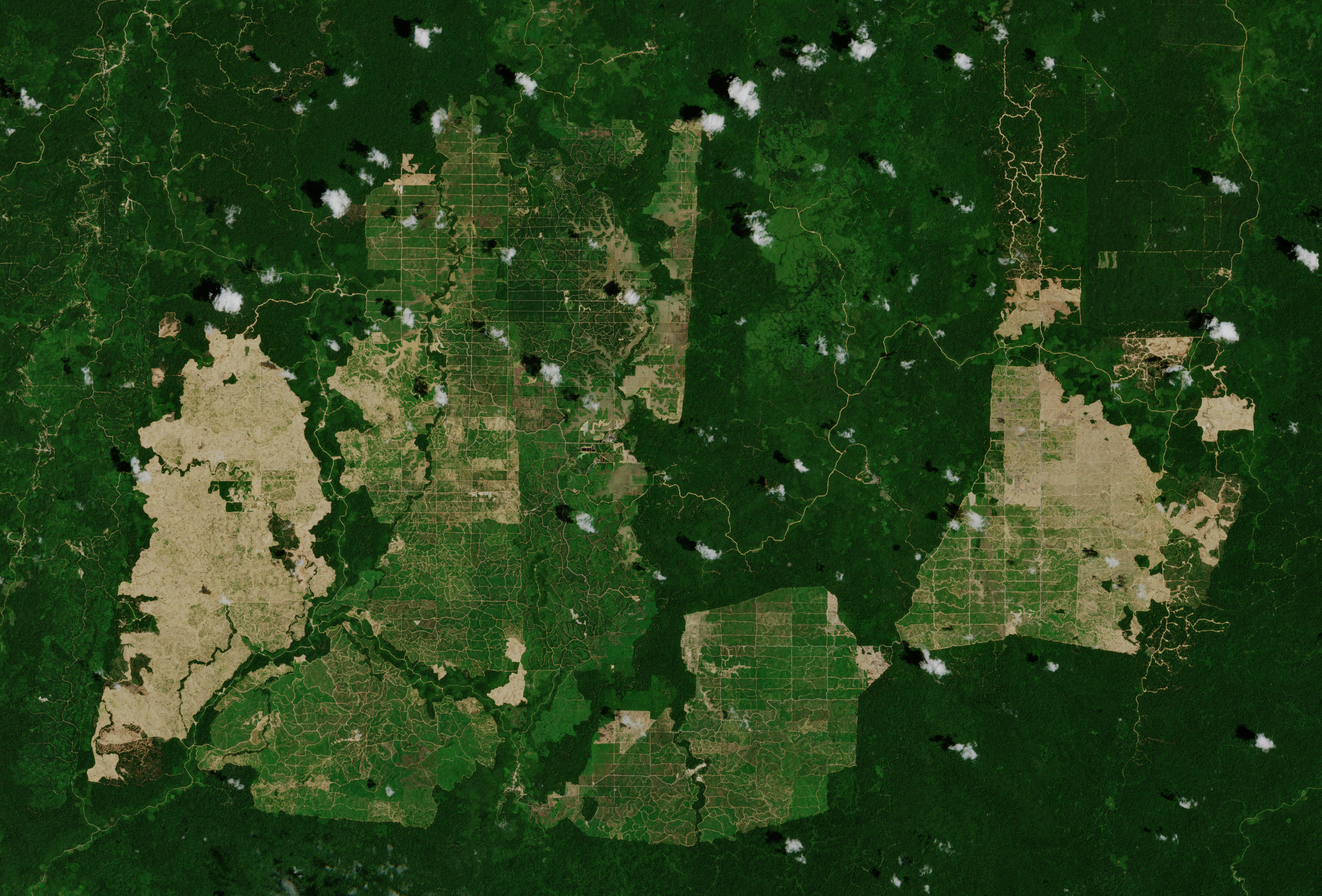
English: The Copernicus Sentinel-2 mission takes us over palm oil plantations in East Kalimantan - the Indonesian part of the island Borneo. Palm oil is the most widely-produced tropical edible oil. It’s used in a vast array of products – from ice cream and chocolates, to cosmetics such as make up and soap, to biofuel. Not only is it versatile, palm oil is also a uniquely productive crop. Harvested all year-round, oil palm trees produce up to nine times more oil per unit area than other major oil crops. To meet global demand, palm oil trees are grown on vast industrial plantations – leading to acres of rainforest being cut down. Between 1980 and 2014, global palm oil production increased from 4.5 million tonnes to 70 million tonnes, and is expected to increase. Indonesia is the largest producer of palm oil, followed by Malaysia. Together they account for 84% of the world’s palm oil production. To produce palm oil in large enough quantities to meet growing demand, farmers clear large areas of tropical rainforest to make room for palm plantations. This leads to a loss of habitat for species such as the orangutan – declared as critically endangered by the WWF. In general, burning forests to make room for the crop is also a major source of greenhouse gas emissions. In this image, captured on 15 February 2019, the various stages of the deforestation process are clearly visible – the green patches in the plantations are the well-established palm oil farms, while the light brown patches show the newly-harvested land. The surrounding lush rainforest is visible in dark green. Copernicus Sentinel-2 is a two-satellite mission, used mostly to track changes in the way land is being used, as well as monitoring the health of vegetation. Each satellite carries a high-resolution camera that images Earth’s surface in 13 spectral bands. This image is also featured on the Earth from Space video programme. |
| Date | 19 July 2019 (upload date) |
| Source | Palm oil plantations |
| Author | European Space Agency |
| Other versions |
|
| Activity | Observing the Earth |
| Mission | Sentinel-2 |
| Set | Earth observation image of the week |
| System | Copernicus |

Licensing

|
This image contains data from a satellite in the Copernicus Programme, such as Sentinel-1, Sentinel-2 or Sentinel-3. Attribution is required when using this image.
Attribution: Contains modified Copernicus Sentinel data 2019
The use of Copernicus Sentinel Data is regulated under EU law (Commission Delegated Regulation (EU) No 1159/2013 and Regulation (EU) No 377/2014). Relevant excerpts:
Free access shall be given to GMES dedicated data [...] made available through GMES dissemination platforms [...].
Access to GMES dedicated data [...] shall be given for the purpose of the following use in so far as it is lawful:
GMES dedicated data [...] may be used worldwide without limitations in time.
GMES dedicated data and GMES service information are provided to users without any express or implied warranty, including as regards quality and suitability for any purpose. |
This media was created by the European Space Agency (ESA).
Where expressly so stated, images or videos are covered by the Creative Commons Attribution-ShareAlike 3.0 IGO (CC BY-SA 3.0 IGO) licence, ESA being an Intergovernmental Organisation (IGO), as defined by the CC BY-SA 3.0 IGO licence. The user is allowed under the terms and conditions of the CC BY-SA 3.0 IGO license to Reproduce, Distribute and Publicly Perform the ESA images and videos released under CC BY-SA 3.0 IGO licence and the Adaptations thereof, without further explicit permission being necessary, for as long as the user complies with the conditions and restrictions set forth in the CC BY-SA 3.0 IGO licence, these including that:
See the ESA Creative Commons copyright notice for complete information, and this article for additional details.
|
 | |
This file is licensed under the Creative Commons Attribution-ShareAlike 3.0 IGO license. Attribution: ESA, CC BY-SA IGO 3.0
| ||
File history
Click on a date/time to view the file as it appeared at that time.
| Date/Time | Thumbnail | Dimensions | User | Comment | |
|---|---|---|---|---|---|
| current | 13:21, June 7, 2020 | | 3,753 × 2,544 (11.44 MB) | wikimediacommons>OptimusPrimeBot | #Spacemedia - Upload of https://www.esa.int/var/esa/storage/images/esa_multimedia/images/2019/07/palm_oil_plantations/19484718-1-eng-GB/Palm_oil_plantations.jpg via Commons:Spacemedia |
File usage
The following page uses this file:
