
File:City Lights of Asia and Middle East 2016.png
From The Observatory

Size of this preview: 744 × 600 pixels. Other resolutions: 279 × 225 pixels | 4,960 × 4,000 pixels.
Original file (4,960 × 4,000 pixels, file size: 13.15 MB, MIME type: image/png)
Summary
| Description |
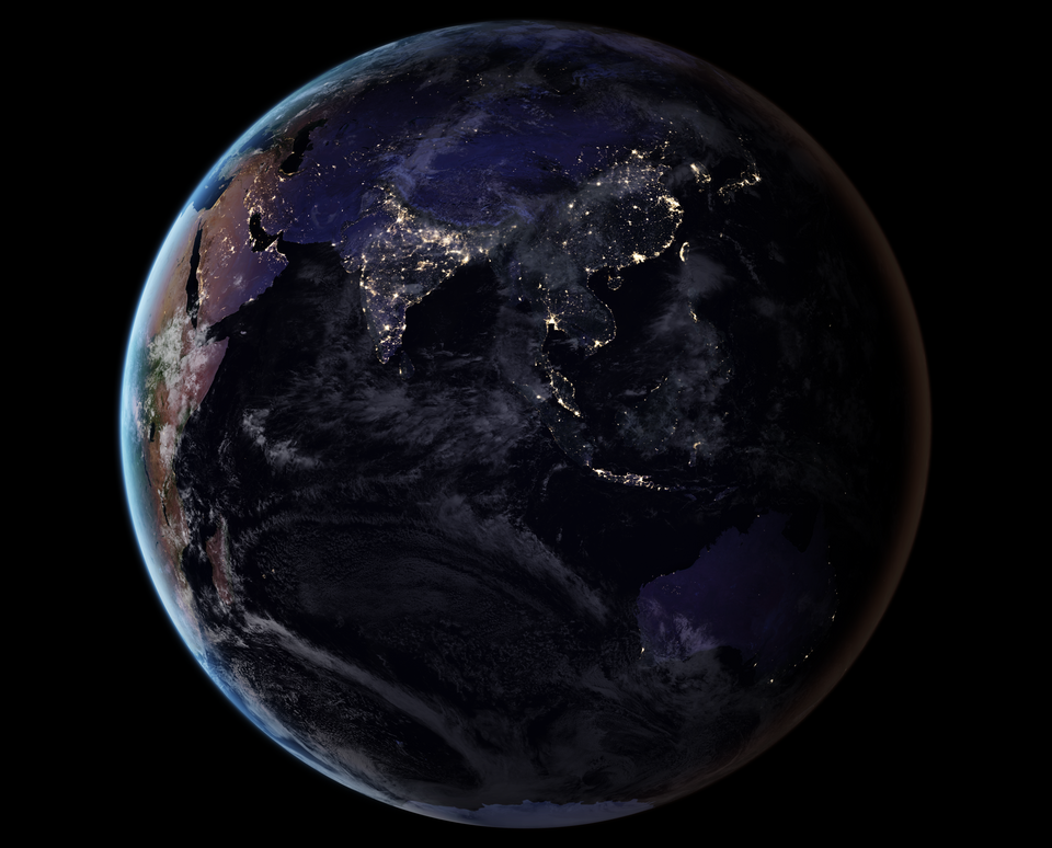
English: This image shows Earth’s night lights as observed in 2016; they are drawn from a 2016 global composite map that was added to Worldview and GIBS. The compositing technique selected the best cloud-free nights in each month over each land mass. (Note that clouds and sunlight are added to the image for aesthetic effect; those data are drawn from the Blue Marble products.)
Instrument: Suomi NPP - VIIRS
Español: Imagen de la Tierra que muestra las luces nocturnas en 2016. Se extrajo de un mapa compuesto global de 2016.
Українська: Земля з космосу, складена з глобальної панорамної карти 2016 року, на якій показано нічні вогні міст. |
| Date | |
| Source | https://earthobservatory.nasa.gov/images/90008/night-light-maps-open-up-new-applications |
| Author | NASA Earth Observatory |
Assessment
|
This image was selected as picture of the day on Wikimedia Commons for 23 September 2024. It was captioned as follows: English: Realistic Earth drawn from the 2016 global composite map showing night lights from Asia and the Middle East. Other languages:
Čeština: Realistická fotografie Země z vesmíru získaná z mapy 2016 globální složené mapy zobrazující noční osvětlená města na Zemi. Deutsch: Fotomontage der Erde aus dem Jahr 2016 mit den Lichtern der Städte bei Nacht. English: Realistic Earth drawn from the 2016 global composite map showing night lights from Asia and the Middle East. Español: Imagen de la Tierra que muestra las luces nocturnas en 2016. Se extrayó de un mapa compuesto global de 2016. Euskara: Lurra espaziotik ikusia, gaueko argiekin, 2016an. Urte horretan sortutako irudi batetik eratorria. Italiano: Immagine della Terra realizzata con una composizione di foto satellitari del 2016, selezionando le migliori fotografie notturne prive di nubi, scattate su ciascuna città terrestre. Magyar: A 2016-os globális kompozittérképből rajzolt valósághű Föld, amely a városok éjszakai fényeit mutatja Português: Imagem da Terra mostrando as luzes noturnas em 2016. Foi extraída de um mapa composto global de 2016. Македонски: Земјата со нејзините вечерни светла во 2016 г. Русский: Ночные огни Земли в 2016 году. Изображение было создано из спутниковых фотографий по композиционному методу. Для этого были отобраны снимки с лучшими безоблачными ночами каждого месяца над всеми материками Українська: Земля з космосу, складена з глобальної панорамної карти 2016 року, на якій показано нічні вогні міст. 한국어: 2016년 세계 합성 지도를 기반으로 그린 현실적인 지구는 도시의 야간 조명을 보여준다. |
Licensing
| This file is in the public domain in the United States because it was solely created by NASA. NASA copyright policy states that "NASA material is not protected by copyright unless noted". (See Template:PD-USGov, NASA copyright policy page or JPL Image Use Policy.) | ||
 |
Warnings:
|
File history
Click on a date/time to view the file as it appeared at that time.
| Date/Time | Thumbnail | Dimensions | User | Comment | |
|---|---|---|---|---|---|
| current | 18:20, July 12, 2024 | | 4,960 × 4,000 (13.15 MB) | commonsforobservatory>Redmyname31 | Uploaded a work by NASA Earth Observatory from https://earthobservatory.nasa.gov/images/90008/night-light-maps-open-up-new-applications with UploadWizard |
File usage
The following page uses this file: